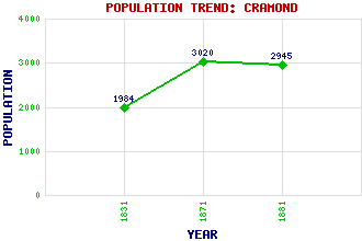
Cramond Classification and Statistics Settlement Type: suburb Population (1881): 2945 (1871): 3020 (1831): 1984 Tourist Rating: Text of Entry Updated: 17-SEP-2015 Location Latitude: 55.9773°N Longitude: 3.2995°W National Grid Reference: NT 190 768 A range of modern and historical maps are accessible through the map tab on the right of this page Get directions by entering the UK postcode of your location, home or hotel here eg. EH1 3YT Use the tabs on the right of this page to see other parts of this entry Related Entries There are 29 related entries. (8 Attractions, 1 Council Area, 1 Historical County, 9 Features, 1 Parish, 5 People and 4 Settlements) Names that are not linked do not currently contain any information. Attractions: Cramond Island Cramond Parish Church Cramond Roman Fort Dere Street John Muir Way Lauriston Castle Museum of Scotland, The Old Cramond Brig Council Area: City of Edinburgh Features: Almond Valley Almond, River Braepark Caer Amon Cramond Bridge Cramond House Cramond Tower Drum Sands Eagle Rock Historical Counties: Midlothian Parishes: Edinburgh People: Thomas Edington William Ewart Gladstone Richard Murphy Joanne Kathleen Rowling(J. K. Rowling) John Philp Wood(Honest John Wood) Settlements: Barnton Dalmeny Davidson's Mains Edinburgh
There are 29 related entries. (8 Attractions, 1 Council Area, 1 Historical County, 9 Features, 1 Parish, 5 People and 4 Settlements)
Names that are not linked do not currently contain any information.
By using our site you agree to accept cookies, which help us serve you better