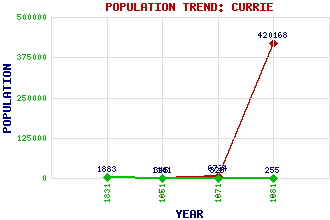
Currie Classification and Statistics Settlement Type: suburb Population (1981): 420168 (Combined with Edinburgh) (1971): 6764 (1951): 1101 (1881): 255 (1871): 329 (1861): 345 (1831): 1883 Tourist Rating: No Text of Entry Updated: 07-AUG-2006 Location Latitude: 55.8954°N Longitude: 3.3096°W National Grid Reference: NT 182 677 A range of modern and historical maps are accessible through the map tab on the right of this page Get directions by entering the UK postcode of your location, home or hotel here eg. EH1 3YT Use the tabs on the right of this page to see other parts of this entry Related Entries There are 32 related entries. (5 Attractions, 1 Council Area, 1 Historical County, 1 Event, 11 Features, 1 Parish, 5 People and 7 Settlements) Names that are not linked do not currently contain any information. Attractions: Colinton Tunnel ICE Scotland Museum Pentland Hills Regional Park Poet's Glen Water of Leith Walkway Council Area: City of Edinburgh Events: Reformation, The Features: Baberton House Currie Community High School Curriehill Curriehill Railway Station Harbour Hill Heriot-Watt University Kinleith Burn Leith, Water of Lennox Tower St Mungo's Well Warklaw Hill Historical Counties: Midlothian Parishes: Currie People: Sir Robert Rowand Anderson Dougal Haston Sir Archibald Johnston(Lord Warriston) Sir John Skene(Lord Curriehill) James Thomson Settlements: Balerno Blinkbonny Edinburgh Juniper Green Kinleith Long Hermiston Riccarton
There are 32 related entries. (5 Attractions, 1 Council Area, 1 Historical County, 1 Event, 11 Features, 1 Parish, 5 People and 7 Settlements)
Names that are not linked do not currently contain any information.
By using our site you agree to accept cookies, which help us serve you better