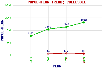
Collessie Classification and Statistics Settlement Type: hamlet Population (2001): 85 (1991): 110 (1961): 70 (1881): 1982(For Parish) (1871): 1703(For Parish) (1861): 1560(For Parish) (1831): 1162(For Parish) Tourist Rating: Text of Entry Updated: 11-JUL-2009 Location Latitude: 56.3067°N Longitude: 3.1555°W National Grid Reference: NO 286 133 A range of modern and historical maps are accessible through the map tab on the right of this page Get directions by entering the UK postcode of your location, home or hotel here eg. EH1 3YT Use the tabs on the right of this page to see other parts of this entry Related Entries There are 15 related entries. (3 Attractions, 1 Council Area, 1 Historical County, 5 Features, 1 Parish, 1 Person and 3 Settlements) Names that are not linked do not currently contain any information. Attractions: Birnie & Gaddon Lochs Nature Reserve Collessie Standing Stone Fife Zoo Council Area: Fife Features: Birnie Loch Collessie Church Gaddon Loch Howe of Fife Monimail Tower Historical Counties: Fife Parishes: Collessie People: Henry Balnaves Settlements: Cupar Giffordtown Monimail
There are 15 related entries. (3 Attractions, 1 Council Area, 1 Historical County, 5 Features, 1 Parish, 1 Person and 3 Settlements)
Names that are not linked do not currently contain any information.
By using our site you agree to accept cookies, which help us serve you better