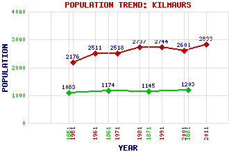
Kilmaurs Classification and Statistics Settlement Type: village Population (2011): 2833 (2001): 2601 (1991): 2744 (1981): 2737 (1971): 2518 (1961): 2511 (1951): 2176 (1881): 1203 (1871): 1145 (1861): 1174 (1851): 1083 Tourist Rating: N/A Text of Entry Updated: 19-SEP-2003 Location Latitude: 55.6382°N Longitude: 4.5276°W National Grid Reference: NS 410 412 A range of modern and historical maps are accessible through the map tab on the right of this page Get directions by entering the UK postcode of your location, home or hotel here eg. EH1 3YT Use the tabs on the right of this page to see other parts of this entry Related Entries There are 17 related entries. (3 Attractions, 1 Council Area, 1 Historical County, 5 Features, 1 Parish, 2 People and 4 Settlements) Names that are not linked do not currently contain any information. Attractions: Kilmaurs Place Kilmaurs Tolbooth Rowallan Castle Council Area: East Ayrshire Features: Carmel Water Garrier Burn Kilmaurs Railway Station Rowallan Castle Golf Club Rowallan House Historical Counties: Ayrshire Parishes: Kilmaurs People: John Boyd Orr(Lord Boyd Orr of Brechin) John (Jack) Cannon Settlements: Crosshouse Cunninghamhead Kilmarnock Knockentiber
There are 17 related entries. (3 Attractions, 1 Council Area, 1 Historical County, 5 Features, 1 Parish, 2 People and 4 Settlements)
Names that are not linked do not currently contain any information.
By using our site you agree to accept cookies, which help us serve you better