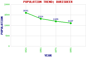
Durisdeer Classification and Statistics Settlement Type: hamlet Population (1881): 1107 (1871): 1189 (1861): 1320 (1821): 1601 Tourist Rating: N/A Text of Entry Updated: 26-JUL-2015 Location Latitude: 55.3131°N Longitude: 3.7425°W National Grid Reference: NS 895 035 A range of modern and historical maps are accessible through the map tab on the right of this page Get directions by entering the UK postcode of your location, home or hotel here eg. EH1 3YT References and Further Reading Gifford, John (1996) The Buildings of Scotland: Dumfries and Galloway. Penguin, London Use the tabs on the right of this page to see other parts of this entry Related Entries There are 22 related entries. (0 Attractions, 1 Council Area, 1 Historical County, 13 Features, 1 Parish, 3 People and 3 Settlements) Names that are not linked do not currently contain any information. Council Area: Dumfries and Galloway Features: Black Hill Clydesdale Dalveen Pass Durisdeer Hill Glenleith Fell Kettleton Reservoir Lamb Hill Little Scawd Law Lowther Hills Nithsdale Pettylung Scawd Law Shiel Dod Historical Counties: Dumfriesshire Parishes: Durisdeer People: John Buchan(1st Baron Tweedsmuir) Sir Ludovic Kennedy Moira Shearer(Lady Kennedy; Moira Shearer King) Settlements: Dalveen Durisdeermill Thornhill
There are 22 related entries. (0 Attractions, 1 Council Area, 1 Historical County, 13 Features, 1 Parish, 3 People and 3 Settlements)
Names that are not linked do not currently contain any information.
By using our site you agree to accept cookies, which help us serve you better