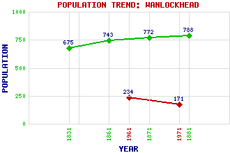
Wanlockhead Classification and Statistics Settlement Type: village Population (1971): 171 (1961): 234 (1881): 788 (1871): 772 (1861): 743 (1831): 675 Tourist Rating: N/A Text of Entry Updated: 03-FEB-2007 Location Latitude: 55.3961°N Longitude: 3.7809°W National Grid Reference: NS 873 128 A range of modern and historical maps are accessible through the map tab on the right of this page Get directions by entering the UK postcode of your location, home or hotel here eg. EH1 3YT Use the tabs on the right of this page to see other parts of this entry Related Entries There are 35 related entries. (4 Attractions, 1 Council Area, 1 Historical County, 23 Features, 1 Parish, 1 Person and 4 Settlements) Names that are not linked do not currently contain any information. Attractions: Leadhills and Wanlockhead Railway, The Museum of Lead Mining Southern Upland Way Wanlockhead Beam Engine Council Area: Dumfries and Galloway Features: Bail Hill Black Hill Brown Hill East Mount Lowther Enterkin Pass Glendorch Burn Glendyne Pass Glengonnar Halt Green Hill Green Lowther Lowther Hills Mennock Pass Mennock Water Mine Hill Snar Water Sowen Dod Stood Hill Thirstane Hill Wanlock Water Wether Hill White Dod Whiteside Willowgrain Hill Historical Counties: Dumfriesshire Parishes: Sanquhar People: William Symington Settlements: Elvanfoot Leadhills Mennock Woodhead
There are 35 related entries. (4 Attractions, 1 Council Area, 1 Historical County, 23 Features, 1 Parish, 1 Person and 4 Settlements)
Names that are not linked do not currently contain any information.
By using our site you agree to accept cookies, which help us serve you better