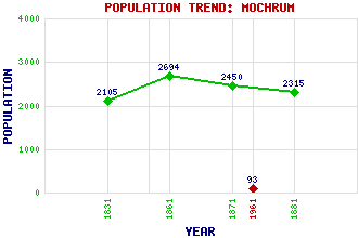
Mochrum (Kirk of Mochrum) Classification and Statistics Settlement Type: hamlet Population (1961): 93 (1881): 2315 (1871): 2450 (1861): 2694 (1831): 2105 Tourist Rating: N/A Text of Entry Updated: 13-NOV-2004 Location Latitude: 54.786°N Longitude: 4.5721°W National Grid Reference: NX 347 465 A range of modern and historical maps are accessible through the map tab on the right of this page Get directions by entering the UK postcode of your location, home or hotel here eg. EH1 3YT Use the tabs on the right of this page to see other parts of this entry Related Entries There are 17 related entries. (0 Attractions, 1 Council Area, 1 Historical County, 8 Features, 1 Parish, 1 Person and 5 Settlements) Names that are not linked do not currently contain any information. Council Area: Dumfries and Galloway Features: Blairshinnoch Hill Corhulloch Hill Derry Hill Druchtag Motte Drumneil Drumwhodya Elrig Loch Mochrum Loch Historical Counties: Wigtownshire Parishes: Mochrum People: Sir William Dunbar Settlements: Barrachan Corhulloch Craigendous Loch Head Wigtown
There are 17 related entries. (0 Attractions, 1 Council Area, 1 Historical County, 8 Features, 1 Parish, 1 Person and 5 Settlements)
Names that are not linked do not currently contain any information.
By using our site you agree to accept cookies, which help us serve you better