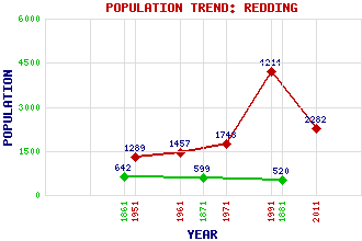
Redding Classification and Statistics Settlement Type: suburb Population (2011): 2282 (1991): 4214 (1971): 1743 (1961): 1457 (1951): 1289 (1881): 520 (1871): 599 (1861): 642 Tourist Rating: No Text of Entry Updated: 11-MAY-2011 Location Latitude: 55.9863°N Longitude: 3.7295°W National Grid Reference: NS 921 783 A range of modern and historical maps are accessible through the map tab on the right of this page Get directions by entering the UK postcode of your location, home or hotel here eg. EH1 3YT References and Further Reading Jaques, Richard (2001) Falkirk and District: An Illustrated Architectural Guide. The Rutland Press, Edinburgh Use the tabs on the right of this page to see other parts of this entry Related Entries There are 12 related entries. (1 Attraction, 1 Council Area, 1 Historical County, 1 Event, 1 Feature, 1 Parish, 0 People and 6 Settlements) Names that are not linked do not currently contain any information. Attractions: Union Canal Council Area: Falkirk Events: Redding Mining Disaster Features: Edinburgh-Dunblane Line Historical Counties: Stirlingshire Parishes: Grangemouth Settlements: Brightons Falkirk Laurieston Polmont Reddingmuirhead Shieldhill
There are 12 related entries. (1 Attraction, 1 Council Area, 1 Historical County, 1 Event, 1 Feature, 1 Parish, 0 People and 6 Settlements)
Names that are not linked do not currently contain any information.
By using our site you agree to accept cookies, which help us serve you better