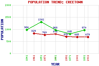
Creetown Classification and Statistics Settlement Type: village Population (2011): 679 (2001): 685 (1991): 692 (1981): 808 (1971): 769 (1961): 829 (1881): 970 (1871): 805 (1861): 968 (1851): 1302 (1841): 984 Tourist Rating: No Text of Entry Updated: 18-MAR-2007 Location Latitude: 54.8969°N Longitude: 4.3795°W National Grid Reference: NX 475 584 A range of modern and historical maps are accessible through the map tab on the right of this page Get directions by entering the UK postcode of your location, home or hotel here eg. EH1 3YT Use the tabs on the right of this page to see other parts of this entry Related Entries There are 23 related entries. (8 Attractions, 1 Council Area, 1 Historical County, 6 Features, 1 Parish, 2 People and 4 Settlements) Names that are not linked do not currently contain any information. Attractions: Balloch Wood Cairnholy Carsluith Castle Creetown Gem Rock Museum Creetown Heritage Museum Kirkdale Sawmill Westerkirk Library Wigtown Bay Local Nature Reserve Council Area: Dumfries and Galloway Features: Cairnharrow Cassencarie Cree, River Kirkdale House Pibble Hill Ravenshall Point Historical Counties: Kirkcudbrightshire Parishes: Kirkmabreck People: William Daniell Sir James Gowans Settlements: Carsluith Kirkmabreck Newton Stewart Pibble
There are 23 related entries. (8 Attractions, 1 Council Area, 1 Historical County, 6 Features, 1 Parish, 2 People and 4 Settlements)
Names that are not linked do not currently contain any information.
By using our site you agree to accept cookies, which help us serve you better