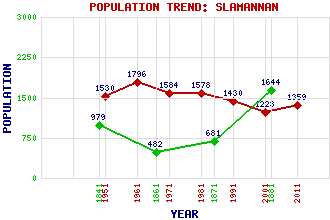
Slamannan Classification and Statistics Settlement Type: village Population (2011): 1359 (2001): 1223 (1991): 1430 (1981): 1578 (1971): 1584 (1961): 1796 (1951): 1530 (1881): 1644 (1871): 681 (1861): 482 (1841): 979 Tourist Rating: No Text of Entry Updated: 02-OCT-2002 Location Latitude: 55.9372°N Longitude: 3.8345°W National Grid Reference: NS 855 731 A range of modern and historical maps are accessible through the map tab on the right of this page Get directions by entering the UK postcode of your location, home or hotel here eg. EH1 3YT References and Further Reading Jaques, Richard (2001) Falkirk and District: An Illustrated Architectural Guide. The Rutland Press, Edinburgh Use the tabs on the right of this page to see other parts of this entry Related Entries There are 18 related entries. (1 Attraction, 1 Council Area, 1 Historical County, 1 Event, 5 Features, 1 Parish, 2 People and 6 Settlements) Names that are not linked do not currently contain any information. Attractions: Mannan, Stone of Council Area: Falkirk Events: Reformation, The Features: Avon, River Black Loch Darnrig Moss Little Black Loch Westquarter Burn Historical Counties: Stirlingshire Parishes: Slamannan People: (Alexander) Iain Calder Joseph (Joe) Corrie Settlements: Avonbridge Caldercruix Camelon Falkirk Jawcraig Limerigg
There are 18 related entries. (1 Attraction, 1 Council Area, 1 Historical County, 1 Event, 5 Features, 1 Parish, 2 People and 6 Settlements)
Names that are not linked do not currently contain any information.
By using our site you agree to accept cookies, which help us serve you better