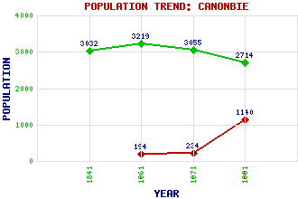
Canonbie Classification and Statistics Settlement Type: village Population (1991): 1140 (1971): 234 (1961): 194 (1881): 2714 (1871): 3055 (1861): 3219 (1841): 3032 Tourist Rating: N/A Text of Entry Updated: 18-SEP-2003 Location Latitude: 55.0765°N Longitude: 2.9553°W National Grid Reference: NY 391 762 A range of modern and historical maps are accessible through the map tab on the right of this page Get directions by entering the UK postcode of your location, home or hotel here eg. EH1 3YT Use the tabs on the right of this page to see other parts of this entry Related Entries There are 27 related entries. (4 Attractions, 1 Council Area, 1 Historical County, 9 Features, 1 Parish, 0 People and 11 Settlements) Names that are not linked do not currently contain any information. Attractions: Devil's Porridge, The Gilnockie Tower Harelaw Limestone Quarry, The Scot's Dyke Council Area: Dumfries and Galloway Features: A7 Trunk Road Byre Burn Debatable Lands, The Esk, River Eskdale Glenzier Burn Liddel Water Liddesdale Riddings Viaduct Historical Counties: Dumfriesshire Parishes: Canonbie Settlements: Byreburnfoot Caerlanrig Caulside Chapelknowe Evertown Harelaw Harelawhole Hollows Milltown Rowanburn Woodhouselees
There are 27 related entries. (4 Attractions, 1 Council Area, 1 Historical County, 9 Features, 1 Parish, 0 People and 11 Settlements)
Names that are not linked do not currently contain any information.
By using our site you agree to accept cookies, which help us serve you better