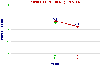
Reston Classification and Statistics Settlement Type: village Population (1971): 280 (1961): 335 (1881): 321 Tourist Rating: N/A Text of Entry Updated: 06-MAY-2019 Location Latitude: 55.851°N Longitude: 2.1932°W National Grid Reference: NT 880 620 A range of modern and historical maps are accessible through the map tab on the right of this page Get directions by entering the UK postcode of your location, home or hotel here eg. EH1 3YT Use the tabs on the right of this page to see other parts of this entry Related Entries There are 13 related entries. (0 Attractions, 1 Council Area, 1 Historical County, 4 Features, 1 Parish, 2 People and 4 Settlements) Names that are not linked do not currently contain any information. Council Area: Scottish Borders Features: East Coast Main Line Eye Water Ferney Castle Reston Railway Station Historical Counties: Berwickshire Parishes: Coldingham People: Timothy Pont Major General William Roy Settlements: Coldingham Duns Edinburgh Eyemouth
There are 13 related entries. (0 Attractions, 1 Council Area, 1 Historical County, 4 Features, 1 Parish, 2 People and 4 Settlements)
Names that are not linked do not currently contain any information.
By using our site you agree to accept cookies, which help us serve you better