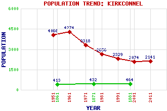
Kirkconnel Classification and Statistics Settlement Type: village Population (2011): 2141 (2001): 2074 (1991): 2329 (1981): 2656 (1971): 3318 (1961): 4274 (1951): 4066 (1881): 464 (1871): 432 (1861): 413 Tourist Rating: No Text of Entry Updated: 04-JUN-2008 Location Latitude: 55.3865°N Longitude: 3.9984°W National Grid Reference: NS 735 121 A range of modern and historical maps are accessible through the map tab on the right of this page Get directions by entering the UK postcode of your location, home or hotel here eg. EH1 3YT Use the tabs on the right of this page to see other parts of this entry Related Entries There are 38 related entries. (0 Attractions, 1 Council Area, 1 Historical County, 17 Features, 14 Parishes, 1 Person and 4 Settlements) Names that are not linked do not currently contain any information. Council Area: Dumfries and Galloway Features: Afton Reservoir Auchtitench Hill Bail Hill Black Hill Castle Hill Cocker Hill Dryfeston Hill Guffock Hill Halfmerk Hill Kiln Burn Kirkconnel Railway Station Lethans Hill Polholm Rig Sanquhar Community Wind Farm Spango Water Stony Hill White Hill Historical Counties: Dumfriesshire Parishes: Auchinleck Carsphairn Crawfordjohn Dalry Douglas Durisdeer Glencairn Keir Kirkconnel New Cumnock Old Cumnock Penpont Sanquhar Tynron People: Alexander Anderson Settlements: Clocklowie Gateside Kelloholm Kelloside
There are 38 related entries. (0 Attractions, 1 Council Area, 1 Historical County, 17 Features, 14 Parishes, 1 Person and 4 Settlements)
Names that are not linked do not currently contain any information.
By using our site you agree to accept cookies, which help us serve you better