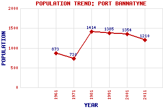
Port Bannatyne (Kamesburgh) Classification and Statistics Settlement Type: village Population (2011): 1210 (2001): 1354 (1991): 1385 (1981): 1414 (1971): 730 (1961): 873 Tourist Rating: N/A Text of Entry Updated: 29-AUG-2018 Location Latitude: 55.8596°N Longitude: 5.0694°W National Grid Reference: NS 080 671 A range of modern and historical maps are accessible through the map tab on the right of this page Get directions by entering the UK postcode of your location, home or hotel here eg. EH1 3YT Use the tabs on the right of this page to see other parts of this entry Related Entries There are 25 related entries. (0 Attractions, 1 Council Area, 1 Historical County, 13 Features, 1 Parish, 2 People and 7 Settlements) Names that are not linked do not currently contain any information. Council Area: Argyll and Bute Features: Ardbeg Point Ardmaleish Point Bute Bute, Kyles of Edinbeg Hill Kames Bay Kames Castle Port Bannatyne Golf Club Rothesay Bay Striven, Loch Undraynian Point West Island Way Windy Hill Historical Counties: Bute and Arran Parishes: North Bute People: Prof. Sir William MacEwen John Mossman Settlements: Ardbeg Ardmaleish Balnakailly Cranslagmory Rothesay St Colmac Stuck
There are 25 related entries. (0 Attractions, 1 Council Area, 1 Historical County, 13 Features, 1 Parish, 2 People and 7 Settlements)
Names that are not linked do not currently contain any information.
By using our site you agree to accept cookies, which help us serve you better