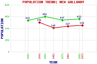
New Galloway Classification and Statistics Settlement Type: village Population (1971): 338 (1961): 327 (1951): 305 (1901): 376(Municipal Burgh) (1881): 422 (1871): 407 (1861): 452 (1841): 403 Tourist Rating: Text of Entry Updated: 27-JUL-2009 Location Latitude: 55.0847°N Longitude: 4.1415°W National Grid Reference: NX 634 788 A range of modern and historical maps are accessible through the map tab on the right of this page Get directions by entering the UK postcode of your location, home or hotel here eg. EH1 3YT Use the tabs on the right of this page to see other parts of this entry Related Entries There are 45 related entries. (0 Attractions, 1 Council Area, 1 Historical County, 25 Features, 1 Parish, 4 People and 13 Settlements) Names that are not linked do not currently contain any information. Council Area: Dumfries and Galloway Features: Benbrack Bennan Blackcraig Hill Cairn Edward Hill Cairnsmore of Dee Carlingwark Lane Canal Clatteringshaws Loch Corserine Fleet, Fell of Galloway Galloway Hydro-Electric Power Scheme Garple Burn Glenkens, The Ken, Loch Ken, Water of Kenmure Castle Kirkcudbrightshire Larglear Hill Lowes Lochs Meikle Millyea Millfire New Galloway Golf Club New Galloway Station Queen's Way, The Skae, Loch Historical Counties: Kirkcudbrightshire Parishes: Kells People: Samuel (Sam) Heughan Queen Mary(Mary, Queen of Scots) Alexander Murray John Rennie Settlements: Airds of Kells Balmaclellan Bogue Corsock Craigdews Dunkitterick Ironmacannie Kirkcudbright Knocklea Laurieston Mossdale St John's Town of Dalry Talnotry
There are 45 related entries. (0 Attractions, 1 Council Area, 1 Historical County, 25 Features, 1 Parish, 4 People and 13 Settlements)
Names that are not linked do not currently contain any information.
By using our site you agree to accept cookies, which help us serve you better