|
|
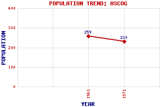
Ascog
Classification and Statistics
|
|
Location
|
References and Further Reading
McDowall, David (2010) Bute. The Laird Press, Richmond, SurreyTranter, Nigel (1977) The Queen's Scotland: Argyll and Bute. Hodder and Stoughton, LondonWalker, Frank Arneil, with Fiona Sinclair (1992) North Clyde Estuary: An Illustrated Architectural Guide. The Royal Incorporation of Architects in Scotland, EdinburghWalker, Frank Arneil (2000) The Buildings of Scotland: Argyll and Bute. Penguin, London
| Use the tabs on the right of this page to see other parts of this entry |
 |
Related Entries
There are 30 related entries.
(1 Attraction,
1 Council Area,
1 Historical County,
1 Event,
14 Features,
1 Parish,
5 People and
6 Settlements)
Names that are not linked do not currently contain any information.
|
|
|
If you have found this information useful please consider making
a donation to help maintain and improve this resource. More info...
|
By using our site you agree to accept cookies, which help us serve you better
|
|
|