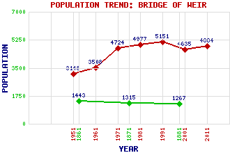
Bridge of Weir Classification and Statistics Settlement Type: village Population (2011): 4884 (2001): 4635 (1991): 5151 (1981): 4977 (1971): 4724 (1961): 3508 (1951): 3148 (1881): 1267 (1871): 1315 (1861): 1443 Tourist Rating: Text of Entry Updated: 26-AUG-2013 Location Latitude: 55.8573°N Longitude: 4.5802°W National Grid Reference: NS 386 657 A range of modern and historical maps are accessible through the map tab on the right of this page Get directions by entering the UK postcode of your location, home or hotel here eg. EH1 3YT Use the tabs on the right of this page to see other parts of this entry Related Entries There are 20 related entries. (0 Attractions, 1 Council Area, 1 Historical County, 1 Family, 7 Features, 1 Parish, 4 People and 5 Settlements) Names that are not linked do not currently contain any information. Council Area: Renfrewshire Families: Knox Features: Gryfe, River Houstonhead Dam Old Course Ranfurly, The Ranfurly Castle Ranfurly Castle Golf Club Thornlybank Hill Union Street Tunnel Historical Counties: Renfrewshire Parishes: Houston and Killellan People: John Archibald Campbell William (Willie) Campbell Alistair (Ally) McCoist William Teacher Settlements: Carruth Crosslee Paisley Quarrier's Village Ranfurly
There are 20 related entries. (0 Attractions, 1 Council Area, 1 Historical County, 1 Family, 7 Features, 1 Parish, 4 People and 5 Settlements)
Names that are not linked do not currently contain any information.
By using our site you agree to accept cookies, which help us serve you better