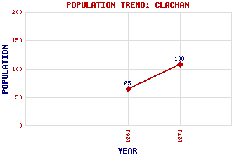
Clachan Classification and Statistics Settlement Type: village Population (1971): 108 (1961): 65 Tourist Rating: N/A Text of Entry Updated: 25-AUG-2006 Location Latitude: 55.7465°N Longitude: 5.5626°W National Grid Reference: NR 765 561 A range of modern and historical maps are accessible through the map tab on the right of this page Get directions by entering the UK postcode of your location, home or hotel here eg. EH1 3YT Use the tabs on the right of this page to see other parts of this entry Related Entries There are 19 related entries. (1 Attraction, 1 Council Area, 1 Historical County, 1 Family, 8 Features, 1 Parish, 2 People and 4 Settlements) Names that are not linked do not currently contain any information. Attractions: Kintyre Way Council Area: Argyll and Bute Families: Alasdair Features: Ciaran, Loch Cnoc an t-Samhlaidh Cruach nam Fiadh Garasdale, Loch Kilblaan Burn Kintyre Loup Hill West Loch Tarbert Historical Counties: Argyllshire Parishes: Kilcalmonell People: King James VII(King James II of England) Sir William Mackinnon Settlements: Ardencaple Loup Portachoillan Tarbert
There are 19 related entries. (1 Attraction, 1 Council Area, 1 Historical County, 1 Family, 8 Features, 1 Parish, 2 People and 4 Settlements)
Names that are not linked do not currently contain any information.
By using our site you agree to accept cookies, which help us serve you better