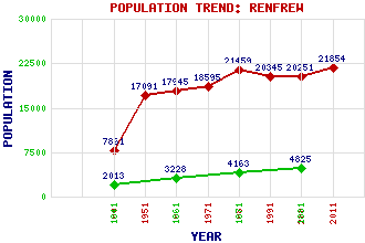
Renfrew Classification and Statistics Settlement Type: town Population (2011): 21854 (2001): 20251 (1991): 20345 (1981): 21459 (1971): 18595 (1961): 17945 (1951): 17091 (1901): 7861(Parliamentary Burgh) (1881): 4825 (1871): 4163 (1861): 3228 (1841): 2013 Tourist Rating: Text of Entry Updated: 11-AUG-2015 Location Latitude: 55.8774°N Longitude: 4.388°W National Grid Reference: NS 507 675 A range of modern and historical maps are accessible through the map tab on the right of this page Get directions by entering the UK postcode of your location, home or hotel here eg. EH1 3YT Use the tabs on the right of this page to see other parts of this entry Related Entries There are 33 related entries. (5 Attractions, 1 Council Area, 1 Historical County, 11 Features, 1 Parish, 11 People and 3 Settlements) Names that are not linked do not currently contain any information. Attractions: Argyll Stone Braehead Centre Marjory Bruce Monument Scottish Maritime Museum, The Xscape Braehead Council Area: Renfrewshire Features: Blythswood Cart, River Clyde, River Glasgow Airport Hillington Industrial Estate Inchinnan Bridge M8 Motorway Renfrew Golf Club Renfrew High School Trinity High School White Cart Water Historical Counties: Renfrewshire Parishes: Renfrew People: James (Jimmy) Airlie William Barclay John Archibald Campbell Walter Fitz Alan Thomas Grainger Ellen King(Ellen Pearson) Thomas (Tom) Leonard John Scott Maclay(Viscount Muirshiel) Rev. Canon John Macquarrie Andrew Park John Rennie Settlements: Glasgow Paisley Yoker
There are 33 related entries. (5 Attractions, 1 Council Area, 1 Historical County, 11 Features, 1 Parish, 11 People and 3 Settlements)
Names that are not linked do not currently contain any information.
By using our site you agree to accept cookies, which help us serve you better