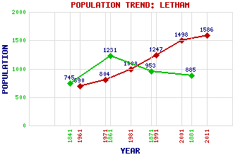
Letham Classification and Statistics Settlement Type: village Population (2011): 1586 (2001): 1498 (1991): 1247 (1981): 1000 (1971): 804 (1961): 690 (1881): 885 (1871): 953 (1861): 1231 (1841): 745 Tourist Rating: No Text of Entry Updated: 01-MAY-2010 Location Latitude: 56.6286°N Longitude: 2.7709°W National Grid Reference: NO 528 488 A range of modern and historical maps are accessible through the map tab on the right of this page Get directions by entering the UK postcode of your location, home or hotel here eg. EH1 3YT Use the tabs on the right of this page to see other parts of this entry Related Entries There are 19 related entries. (0 Attractions, 1 Council Area, 1 Historical County, 1 Event, 5 Features, 1 Parish, 3 People and 7 Settlements) Names that are not linked do not currently contain any information. Council Area: Angus Events: Battle of Nechtanesmere Features: Dunnichen Hill Gardyne Castle Guthrie Castle Nechtansmere Vinny Water Historical Counties: Angus Parishes: Dunnichen People: George Dempster of Dunnichen(Honest George) Stuart McGugan Daniel (Danny) Wallace Settlements: Burnside Craichie Dunnichen Greystone Muir of Lownie West Hills Whigstreet
There are 19 related entries. (0 Attractions, 1 Council Area, 1 Historical County, 1 Event, 5 Features, 1 Parish, 3 People and 7 Settlements)
Names that are not linked do not currently contain any information.
By using our site you agree to accept cookies, which help us serve you better