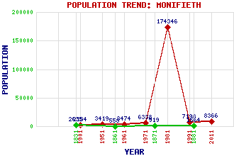
Monifieth Classification and Statistics Settlement Type: small town Population (2011): 8366 (1991): 7198 (1981): 174346(Combined with Dundee) (1971): 6338 (1961): 3474 (1951): 3419 (1901): 2134(Police Burgh) (1881): 1564 (1871): 919 (1861): 558 (1831): 2635 Tourist Rating: No Text of Entry Updated: 11-APR-2010 Location Latitude: 56.4792°N Longitude: 2.8182°W National Grid Reference: NO 497 322 A range of modern and historical maps are accessible through the map tab on the right of this page Get directions by entering the UK postcode of your location, home or hotel here eg. EH1 3YT Use the tabs on the right of this page to see other parts of this entry Related Entries There are 35 related entries. (5 Attractions, 1 Council Area, 1 Historical County, 1 Family, 18 Features, 1 Parish, 4 People and 4 Settlements) Names that are not linked do not currently contain any information. Attractions: Ardestie Earth House Barry Links Bo'ness & Kinneil Railway Carlungie Earth House Monikie Country Park Council Area: Angus Families: Maule Features: Affleck Castle Balmossie Balmossie Halt Barnhill Barry Buddon Training Centre Broughty Golf Club Buddon Burn Dighty Water East Coast Main Line Lady Bank Lady Shoal Monifieth Ashludie Golf Course Monifieth High School Monifieth Links Monifieth Medal Golf Course Monifieth Railway Station Monifieth Sands Tay, Firth of Historical Counties: Angus Parishes: Monifieth People: Saint Andrew(St. Andrew) James Maule(4th Earl of Panmure) Alexander Mylne George Thomson(Lord Thomson of Monifeith) Settlements: Drumsturdy Dundee Monikie Newbigging
There are 35 related entries. (5 Attractions, 1 Council Area, 1 Historical County, 1 Family, 18 Features, 1 Parish, 4 People and 4 Settlements)
Names that are not linked do not currently contain any information.
By using our site you agree to accept cookies, which help us serve you better