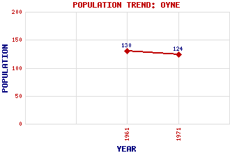
Oyne Classification and Statistics Settlement Type: village Population (1971): 124 (1961): 130 Tourist Rating: N/A Text of Entry Updated: 13-JUN-2019 Location Latitude: 57.3206°N Longitude: 2.5462°W National Grid Reference: NJ 672 257 A range of modern and historical maps are accessible through the map tab on the right of this page Get directions by entering the UK postcode of your location, home or hotel here eg. EH1 3YT Use the tabs on the right of this page to see other parts of this entry Related Entries There are 19 related entries. (2 Attractions, 1 Council Area, 1 Historical County, 8 Features, 1 Parish, 1 Person and 5 Settlements) Names that are not linked do not currently contain any information. Attractions: Archaeolink Prehistory Park Berry Hill Council Area: Aberdeenshire Features: Bennachie Black Hill Candle Hill Craigshannoch Garioch Gowk Stane Lickleyhead Castle Tillymuick Historical Counties: Aberdeenshire Parishes: Oyne People: John Leslie(John Lesley) Settlements: Aberdeen Insch Inverurie Kirkton of Oyne Logie Durno
There are 19 related entries. (2 Attractions, 1 Council Area, 1 Historical County, 8 Features, 1 Parish, 1 Person and 5 Settlements)
Names that are not linked do not currently contain any information.
By using our site you agree to accept cookies, which help us serve you better