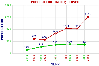
Insch Classification and Statistics Settlement Type: village Population (2011): 2282 (2001): 1523 (1991): 1541 (1981): 1256 (1971): 858 (1961): 917 (1891): 567 (1881): 579 (1871): 533 (1861): 411 (1841): 215 Tourist Rating: N/A Text of Entry Updated: 17-MAR-2011 Location Latitude: 57.341°N Longitude: 2.6163°W National Grid Reference: NJ 630 280 A range of modern and historical maps are accessible through the map tab on the right of this page Get directions by entering the UK postcode of your location, home or hotel here eg. EH1 3YT Use the tabs on the right of this page to see other parts of this entry Related Entries There are 27 related entries. (3 Attractions, 1 Council Area, 1 Historical County, 11 Features, 1 Parish, 0 People and 10 Settlements) Names that are not linked do not currently contain any information. Attractions: Archaeolink Prehistory Park Berry Hill Insch Connection, The Council Area: Aberdeenshire Features: Cairn More Christ's Kirk, Hill of Dunnideer Hill Dunnideer, Castle of Flinder, Hill of Garioch Glens of Foudland Wind Farm Insch Golf Club Insch Railway Station Knock Saul Shevock, The Historical Counties: Aberdeenshire Parishes: Insch Settlements: Auchleven Colpy Duncanston Dunnideer Glanderston Inverurie Kirkton of Culsalmond Leslie Oyne Rothney
There are 27 related entries. (3 Attractions, 1 Council Area, 1 Historical County, 11 Features, 1 Parish, 0 People and 10 Settlements)
Names that are not linked do not currently contain any information.
By using our site you agree to accept cookies, which help us serve you better