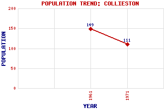
Collieston Classification and Statistics Settlement Type: village Population (1971): 111 (1961): 149 Tourist Rating: No Text of Entry Updated: 18-JUL-2015 Location Latitude: 57.347°N Longitude: 1.9368°W National Grid Reference: NK 039 285 A range of modern and historical maps are accessible through the map tab on the right of this page Get directions by entering the UK postcode of your location, home or hotel here eg. EH1 3YT Use the tabs on the right of this page to see other parts of this entry Related Entries There are 13 related entries. (1 Attraction, 1 Council Area, 1 Historical County, 7 Features, 1 Parish, 1 Person and 1 Settlement) Names that are not linked do not currently contain any information. Attractions: Forvie National Nature Reserve Council Area: Aberdeenshire Features: Cotehill Loch Hackley Bay Hackley Head Meikle Loch Old Slains Castle Sand Loch Ythan, River Historical Counties: Aberdeenshire Parishes: Slains People: Saint Ternan(St. Ternan) Settlements: Kirktown of Slains
There are 13 related entries. (1 Attraction, 1 Council Area, 1 Historical County, 7 Features, 1 Parish, 1 Person and 1 Settlement)
Names that are not linked do not currently contain any information.
By using our site you agree to accept cookies, which help us serve you better