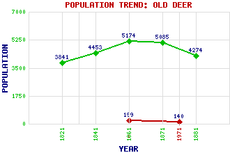
Old Deer Classification and Statistics Settlement Type: settlement Population (1971): 140 (1961): 199 (1881): 4274 (1871): 5085 (1861): 5174 (1841): 4453 (1821): 3841 Tourist Rating: No Text of Entry Updated: 10-JUL-2009 Location Latitude: 57.5212°N Longitude: 2.0383°W National Grid Reference: NJ 978 479 A range of modern and historical maps are accessible through the map tab on the right of this page Get directions by entering the UK postcode of your location, home or hotel here eg. EH1 3YT Use the tabs on the right of this page to see other parts of this entry Related Entries There are 15 related entries. (3 Attractions, 1 Council Area, 1 Historical County, 1 Family, 1 Feature, 1 Parish, 3 People and 4 Settlements) Names that are not linked do not currently contain any information. Attractions: Aberdeenshire Farming Museum, The Aden Country Park Formartine & Buchan Way Council Area: Aberdeenshire Families: Buchan Features: Pitfour Lake Historical Counties: Aberdeenshire Parishes: Old Deer People: Saint Columba(St. Columba or Saint Colum Cille) Sir (John) Ninian Comper Saint Drostan(St. Drostan) Settlements: Clola New Deer Peterhead Stuartfield
There are 15 related entries. (3 Attractions, 1 Council Area, 1 Historical County, 1 Family, 1 Feature, 1 Parish, 3 People and 4 Settlements)
Names that are not linked do not currently contain any information.
By using our site you agree to accept cookies, which help us serve you better