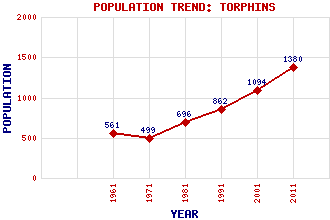
Torphins Classification and Statistics Settlement Type: village Population (2011): 1380 (2001): 1094 (1991): 862 (1981): 696 (1971): 499 (1961): 561 Tourist Rating: N/A Text of Entry Updated: 06-SEP-2007 Location Latitude: 57.1047°N Longitude: 2.6223°W National Grid Reference: NJ 624 017 A range of modern and historical maps are accessible through the map tab on the right of this page Get directions by entering the UK postcode of your location, home or hotel here eg. EH1 3YT Use the tabs on the right of this page to see other parts of this entry Related Entries There are 16 related entries. (1 Attraction, 1 Council Area, 1 Historical County, 7 Features, 1 Parish, 1 Person and 4 Settlements) Names that are not linked do not currently contain any information. Attractions: Deeside Council Area: Aberdeenshire Features: Beltie Burn Cairn Mude Collydean Craigmyle House Gibbet Stone Learney House Torphins Golf Club Historical Counties: Aberdeenshire Parishes: Kincardine O'Neil People: Thomas Shaw(1st Baron Craigmyle) Settlements: Banchory Glassel Kincardine O'Neil Lumphanan
There are 16 related entries. (1 Attraction, 1 Council Area, 1 Historical County, 7 Features, 1 Parish, 1 Person and 4 Settlements)
Names that are not linked do not currently contain any information.
By using our site you agree to accept cookies, which help us serve you better