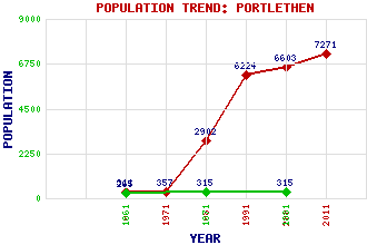
Portlethen Classification and Statistics Settlement Type: small town Population (2011): 7271 (2001): 6603 (1991): 6224 (1981): 2902 (1971): 357 (1961): 311 (1881): 315 (1871): 315 (1861): 265 Tourist Rating: N/A Text of Entry Updated: 04-JUN-2006 Location Latitude: 57.0585°N Longitude: 2.1351°W National Grid Reference: NO 919 964 A range of modern and historical maps are accessible through the map tab on the right of this page Get directions by entering the UK postcode of your location, home or hotel here eg. EH1 3YT Use the tabs on the right of this page to see other parts of this entry Related Entries There are 33 related entries. (0 Attractions, 1 Council Area, 1 Historical County, 11 Features, 12 Parishes, 0 People and 8 Settlements) Names that are not linked do not currently contain any information. Council Area: Aberdeenshire Features: Auchlee, Hill of Badentoy Park Craigmaroinn East Coast Main Line Findon Burn May Craig Netherley Booster Station North Sea Portlethen Academy Portlethen Golf Club Portlethen Railway Station Historical Counties: Kincardineshire Parishes: Aberdeen Banchory-Devenick Banchory-Ternan Drumoak Dunnottar Fetteresso Kinneff and Catterline Maryculter Newhills Nigg Old Machar Peterculter Settlements: Aberdeen Cove Bay Downies Newhall Newtonhill Portlethen Village Roadside of Cookston Stonehaven
There are 33 related entries. (0 Attractions, 1 Council Area, 1 Historical County, 11 Features, 12 Parishes, 0 People and 8 Settlements)
Names that are not linked do not currently contain any information.
By using our site you agree to accept cookies, which help us serve you better