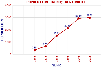
Newtonhill Classification and Statistics Settlement Type: village Population (2011): 2982 (2001): 2940 (1991): 2139 (1981): 1521 (1971): 674 (1961): 348 Tourist Rating: N/A Text of Entry Updated: 05-MAY-2019 Location Latitude: 57.0334°N Longitude: 2.1515°W National Grid Reference: NO 909 936 A range of modern and historical maps are accessible through the map tab on the right of this page Get directions by entering the UK postcode of your location, home or hotel here eg. EH1 3YT Use the tabs on the right of this page to see other parts of this entry Related Entries There are 15 related entries. (0 Attractions, 1 Council Area, 1 Historical County, 4 Features, 1 Parish, 0 People and 8 Settlements) Names that are not linked do not currently contain any information. Council Area: Aberdeenshire Features: Berrymuir Head Clashfarquhar Bay East Coast Main Line May Craig Historical Counties: Kincardineshire Parishes: Fetteresso Settlements: Aberdeen Cammachmore Chapelton Downies Newhall Portlethen Skateraw Stonehaven
There are 15 related entries. (0 Attractions, 1 Council Area, 1 Historical County, 4 Features, 1 Parish, 0 People and 8 Settlements)
Names that are not linked do not currently contain any information.
By using our site you agree to accept cookies, which help us serve you better