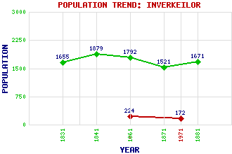
Inverkeilor Classification and Statistics Settlement Type: village Population (1971): 172 (1961): 224 (1881): 1671 (1871): 1521 (1861): 1792 (1841): 1879 (1831): 1655 Tourist Rating: N/A Text of Entry Updated: 03-AUG-2009 Location Latitude: 56.6334°N Longitude: 2.5346°W National Grid Reference: NO 673 492 A range of modern and historical maps are accessible through the map tab on the right of this page Get directions by entering the UK postcode of your location, home or hotel here eg. EH1 3YT Use the tabs on the right of this page to see other parts of this entry Related Entries There are 18 related entries. (0 Attractions, 1 Council Area, 1 Historical County, 6 Families, 6 Features, 1 Parish, 0 People and 3 Settlements) Names that are not linked do not currently contain any information. Council Area: Angus Families: Bruce Carnegie Gardyne Lindsay Rait Ramsay Features: East Coast Main Line Ethie Castle Lang Craig Letham Grange Lunan Water Red Castle Historical Counties: Angus Parishes: Inverkeilor Settlements: Arbroath Chapelton Letham Grange
There are 18 related entries. (0 Attractions, 1 Council Area, 1 Historical County, 6 Families, 6 Features, 1 Parish, 0 People and 3 Settlements)
Names that are not linked do not currently contain any information.
By using our site you agree to accept cookies, which help us serve you better