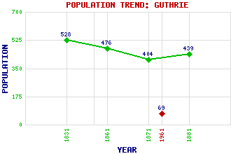
Guthrie Classification and Statistics Settlement Type: hamlet Population (1961): 69 (1881): 439 (1871): 404 (1861): 476 (1831): 528 Tourist Rating: N/A Text of Entry Updated: 09-MAY-2008 Location Latitude: 56.6434°N Longitude: 2.7076°W National Grid Reference: NO 567 504 A range of modern and historical maps are accessible through the map tab on the right of this page Get directions by entering the UK postcode of your location, home or hotel here eg. EH1 3YT Use the tabs on the right of this page to see other parts of this entry Related Entries There are 13 related entries. (1 Attraction, 1 Council Area, 1 Historical County, 1 Event, 3 Features, 1 Parish, 3 People and 2 Settlements) Names that are not linked do not currently contain any information. Attractions: Arbroath Abbey Council Area: Angus Events: Battle of Flodden Features: Gardyne Castle Guthrie Castle House of Pitmuies Historical Counties: Angus Parishes: Guthrie People: Rev. James Guthrie Sir David Guthrie(2nd Lord Kincaldrum; 1st Lord Guthrie) King James III Settlements: Cottown of Guthrie Forfar
There are 13 related entries. (1 Attraction, 1 Council Area, 1 Historical County, 1 Event, 3 Features, 1 Parish, 3 People and 2 Settlements)
Names that are not linked do not currently contain any information.
By using our site you agree to accept cookies, which help us serve you better