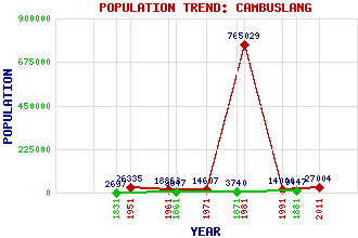
Cambuslang Classification and Statistics Settlement Type: small town Population (2011): 27004 (1991): 14000 (1981): 765029(Combined with Glasgow) (1971): 14607 (1961): 18868 (1951): 26335 (1881): 9447 (1871): 3740 (1861): 3647 (1831): 2697 Tourist Rating: No Text of Entry Updated: 23-MAR-2019 Location Latitude: 55.8186°N Longitude: 4.1689°W National Grid Reference: NS 642 605 A range of modern and historical maps are accessible through the map tab on the right of this page Get directions by entering the UK postcode of your location, home or hotel here eg. EH1 3YT Use the tabs on the right of this page to see other parts of this entry Related Entries There are 41 related entries. (0 Attractions, 1 Council Area, 1 Historical County, 15 Features, 1 Parish, 17 People and 6 Settlements) Names that are not linked do not currently contain any information. Council Area: South Lanarkshire Features: Bogleshole Bridge Cambuslang Bridge Cambuslang Footbridge Cambuslang Railway Station Cathkin High School Clyde, River Clydeford Bridge Croftfoot Gilbertfield Castle High Crosshill Kirkhill Golf Club Kirkhill Railway Station Newton Railway Station Rutherglen High School West Coast Main Line Historical Counties: Lanarkshire Parishes: Cambuslang People: Claudius Buchanan Steven Campbell Peter MacGregor Chalmers David Dale Scott Harrison John Claudius Loudon William McCance Rev. William McCulloch Michael (Mick) McGahey Sir Ian McGregor Sadie McLellan Bernard Ponsonby Rev. James Robe Henry Alexander Hepburne Scott(10th Earl of Polwarth) James (Midge) Ure Michael (Mike) Watson(Lord Watson of Invergowrie) James George Weir Settlements: Eastfield Flemington Newton Rutherglen Silverbank Westburn
There are 41 related entries. (0 Attractions, 1 Council Area, 1 Historical County, 15 Features, 1 Parish, 17 People and 6 Settlements)
Names that are not linked do not currently contain any information.
By using our site you agree to accept cookies, which help us serve you better