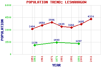
Lesmahagow (Abbey Green) Classification and Statistics Settlement Type: village Population (2011): 4330 (2001): 3685 (1991): 3266 (1981): 3409 (1971): 3906 (1961): 3558 (1951): 3084 (1881): 1297 (1871): 1448 (1861): 1136 Tourist Rating: No Text of Entry Updated: 01-OCT-2010 Location Latitude: 55.6372°N Longitude: 3.8872°W National Grid Reference: NS 813 398 A range of modern and historical maps are accessible through the map tab on the right of this page Get directions by entering the UK postcode of your location, home or hotel here eg. EH1 3YT Use the tabs on the right of this page to see other parts of this entry Related Entries There are 19 related entries. (0 Attractions, 1 Council Area, 1 Historical County, 1 Event, 7 Features, 1 Parish, 2 People and 6 Settlements) Names that are not linked do not currently contain any information. Council Area: South Lanarkshire Events: Reformation, The Features: Dunside Lower Reservoir Dunside Upper Reservoir Hagshaw Hill Hagshaw Hill Wind Farm Hollandbush Golf Club Lesmahagow High School Nethan, River Historical Counties: Lanarkshire Parishes: Lesmahagow People: Sir Alexander (Alec) Kirkland Cairncross Gavin Dalziel(Gavin Dalzell) Settlements: Auchlochan Brocketsbrae Coalburn Cumberhead New Trows Stonehouse
There are 19 related entries. (0 Attractions, 1 Council Area, 1 Historical County, 1 Event, 7 Features, 1 Parish, 2 People and 6 Settlements)
Names that are not linked do not currently contain any information.
By using our site you agree to accept cookies, which help us serve you better