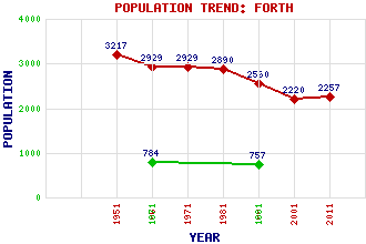
Forth Classification and Statistics Settlement Type: village Population (2011): 2257 (2001): 2220 (1991): 2560 (1981): 2890 (1971): 2929 (1961): 2929 (1951): 3217 (1881): 757 (1871): 784 Tourist Rating: No Text of Entry Updated: 04-JUL-2009 Location Latitude: 55.7641°N Longitude: 3.6893°W National Grid Reference: NS 941 536 A range of modern and historical maps are accessible through the map tab on the right of this page Get directions by entering the UK postcode of your location, home or hotel here eg. EH1 3YT Use the tabs on the right of this page to see other parts of this entry Related Entries There are 14 related entries. (0 Attractions, 1 Council Area, 1 Historical County, 5 Features, 1 Parish, 1 Person and 5 Settlements) Names that are not linked do not currently contain any information. Council Area: South Lanarkshire Features: Black Law Wind Farm Gladsmuir Hills Mouse Water Springfield Reservoir Worm Law Historical Counties: Lanarkshire Parishes: Carnwath People: William (Willie) Waddell Settlements: Climpy Greenwall Rootpark Stobwood Wilsontown
There are 14 related entries. (0 Attractions, 1 Council Area, 1 Historical County, 5 Features, 1 Parish, 1 Person and 5 Settlements)
Names that are not linked do not currently contain any information.
By using our site you agree to accept cookies, which help us serve you better