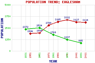
Eaglesham Classification and Statistics Settlement Type: village Population (2011): 3114 (2001): 3127 (1991): 3382 (1981): 3165 (1971): 2788 (1961): 1949 (1951): 1906 (1881): 885 (1871): 1237 (1861): 1769 (1851): 2524 (1831): 2372 Tourist Rating: Text of Entry Updated: 16-AUG-2020 Location Latitude: 55.7394°N Longitude: 4.2729°W National Grid Reference: NS 574 519 A range of modern and historical maps are accessible through the map tab on the right of this page Get directions by entering the UK postcode of your location, home or hotel here eg. EH1 3YT Use the tabs on the right of this page to see other parts of this entry Related Entries There are 34 related entries. (2 Attractions, 1 Council Area, 1 Historical County, 1 Event, 20 Features, 1 Parish, 2 People and 6 Settlements) Names that are not linked do not currently contain any information. Attractions: Statue House, The Whitelee Wind Farm Council Area: East Renfrewshire Events: Hitler's Deputy lands in Scotland Features: Ballageich Hill Bennan Hill Bennan Loch Reservoir Brown Hill Corse Hill Dunwan Burn Dunwan Dam Eaglesham Moor Eaglesham Old and Carswell Parish Church Enoch Burn Laird's Seat Loch Hill Lochgoin Reservoir Melowther Hill Myres Hill Picketlaw Reservoir Polnoon Water Queenseat Hill Rivoch Cut White Cart Water Historical Counties: Renfrewshire Parishes: Eaglesham People: William Gemmell Robert Pollok Settlements: Clarkston East Kilbride Glasgow Jackton Polnoon Strathaven
There are 34 related entries. (2 Attractions, 1 Council Area, 1 Historical County, 1 Event, 20 Features, 1 Parish, 2 People and 6 Settlements)
Names that are not linked do not currently contain any information.
By using our site you agree to accept cookies, which help us serve you better