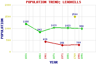
Leadhills Classification and Statistics Settlement Type: village Population (1991): 300 (1971): 286 (1961): 439 (1891): 998 (1881): 1023 (1871): 1033 (1861): 842 (1831): 1188 (1769): 1500 Tourist Rating: N/A Text of Entry Updated: 08-JAN-2021 Location Latitude: 55.4161°N Longitude: 3.7629°W National Grid Reference: NS 885 150 A range of modern and historical maps are accessible through the map tab on the right of this page Get directions by entering the UK postcode of your location, home or hotel here eg. EH1 3YT Use the tabs on the right of this page to see other parts of this entry Related Entries There are 27 related entries. (4 Attractions, 1 Council Area, 1 Historical County, 1 Family, 10 Features, 1 Parish, 4 People and 5 Settlements) Names that are not linked do not currently contain any information. Attractions: Leadhills Miners Library Leadhills and Wanlockhead Railway, The Museum of Lead Mining Scots Mining Company House Council Area: South Lanarkshire Families: Hope Features: Broad Law Glengonnar Halt Glengonnar Water Green Lowther Hopetoun Estate Hunt Law Leadhills Golf Club Lowther Hills Silver Glen Wellgrain Dod Historical Counties: Lanarkshire Parishes: Crawford People: Allan Ramsay James Stirling William Symington James Taylor Settlements: Abington Crawfordjohn Elvanfoot Wanlockhead Woodhead
There are 27 related entries. (4 Attractions, 1 Council Area, 1 Historical County, 1 Family, 10 Features, 1 Parish, 4 People and 5 Settlements)
Names that are not linked do not currently contain any information.
By using our site you agree to accept cookies, which help us serve you better