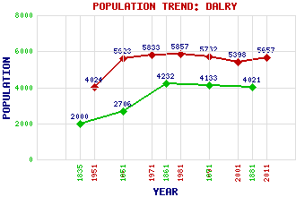
Dalry Classification and Statistics Settlement Type: small town Population (2011): 5657 (2001): 5398 (1991): 5732 (1981): 5857 (1971): 5833 (1961): 5623 (1951): 4024 (1881): 4021 (1871): 4133 (1861): 4232 (1851): 2706 (1835): 2000(Estimate) Tourist Rating: Text of Entry Updated: 04-APR-2020 Location Latitude: 55.7069°N Longitude: 4.7199°W National Grid Reference: NS 292 493 A range of modern and historical maps are accessible through the map tab on the right of this page Get directions by entering the UK postcode of your location, home or hotel here eg. EH1 3YT Use the tabs on the right of this page to see other parts of this entry Related Entries There are 45 related entries. (1 Attraction, 1 Council Area, 1 Historical County, 1 Event, 23 Features, 1 Parish, 7 People and 10 Settlements) Names that are not linked do not currently contain any information. Attractions: Blair Castle Council Area: North Ayrshire Events: Pentland Rising Features: Aitnock Fort Auldmuir Reservoir Ayrshire Coast Line Baidland Hill Bents Hill Bombo Burn Caaf Reservoir Caaf Water Carwinning Hill Cockrobin Hill Cunninghame Dalry Railway Station Garnock Valley Garnock, River Gill Hill Hindog Glen Knockendon Reservoir Law Hill Lynn Glen Millour Hill Community Wind Farm Monk Castle Rye Water Wardlaw Wood Wind Farm Historical Counties: Ayrshire Parishes: Dalry People: Andrew Barclay Robert Burns George Houston Daniel Kerr Alexander Malcomson Alexander Peden Sir Alexander Stevenson Settlements: Beith Brownhill Burnside Drakemyre Highfield Kilbirnie Kilmarnock Kilwinning Munnoch West Kilbride
There are 45 related entries. (1 Attraction, 1 Council Area, 1 Historical County, 1 Event, 23 Features, 1 Parish, 7 People and 10 Settlements)
Names that are not linked do not currently contain any information.
By using our site you agree to accept cookies, which help us serve you better