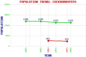
Cockburnspath (Co'path) Classification and Statistics Settlement Type: village Population (1971): 233 (1961): 261 (1881): 1130 (1871): 1133 (1861): 1194 (1851): 1196 Tourist Rating: N/A Text of Entry Updated: 06-MAY-2019 Location Latitude: 55.9315°N Longitude: 2.3632°W National Grid Reference: NT 774 710 A range of modern and historical maps are accessible through the map tab on the right of this page Get directions by entering the UK postcode of your location, home or hotel here eg. EH1 3YT Use the tabs on the right of this page to see other parts of this entry Related Entries There are 28 related entries. (2 Attractions, 1 Council Area, 1 Historical County, 15 Features, 1 Parish, 4 People and 4 Settlements) Names that are not linked do not currently contain any information. Attractions: Sir Walter Scott Way Southern Upland Way Council Area: Scottish Borders Features: A1 Trunk Road Dunglass Dean East Coast Main Line Ecclaw Hill Ewieside Hill Fast Castle Head Lammermuir Hills Meikle Black Law Pease Bay Pease Bridge Pease Dean Reed Point Siccar Point Telegraph Hill Tower Burn Historical Counties: Berwickshire Parishes: Cockburnspath People: John Broadwood Sir James Guthrie Henry Stewart(Lord Methven) Edward Arthur Walton(E.A. Walton) Settlements: Cove Dunbar Dunglass Oldhamstocks
There are 28 related entries. (2 Attractions, 1 Council Area, 1 Historical County, 15 Features, 1 Parish, 4 People and 4 Settlements)
Names that are not linked do not currently contain any information.
By using our site you agree to accept cookies, which help us serve you better