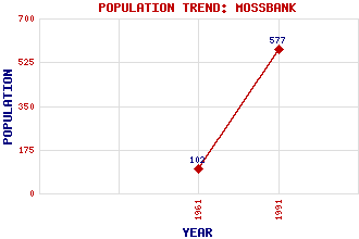
Mossbank Classification and Statistics Settlement Type: village Population (1991): 577 (1961): 102 Tourist Rating: N/A Text of Entry Updated: 19-APR-2011 Location Latitude: 60.4579°N Longitude: 1.1819°W National Grid Reference: HU 451 751 A range of modern and historical maps are accessible through the map tab on the right of this page Get directions by entering the UK postcode of your location, home or hotel here eg. EH1 3YT Use the tabs on the right of this page to see other parts of this entry Related Entries There are 17 related entries. (0 Attractions, 1 Council Area, 1 Historical County, 12 Features, 1 Parish, 0 People and 2 Settlements) Names that are not linked do not currently contain any information. Council Area: Shetland Features: Burra Ness Crooksetter, Hill of Firths Voe Fish Holm Garth, Hill of Houb, The Lee, Hill of Linga Oxnabool, Hill of Samphrey Shetland Mainland Vats Houllands Historical Counties: Shetland Parishes: Delting Settlements: Brough Garth
There are 17 related entries. (0 Attractions, 1 Council Area, 1 Historical County, 12 Features, 1 Parish, 0 People and 2 Settlements)
Names that are not linked do not currently contain any information.
By using our site you agree to accept cookies, which help us serve you better