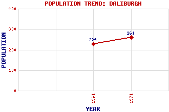
Daliburgh (Dalabrog) Classification and Statistics Settlement Type: hamlet Population (1971): 261 (1961): 229 Tourist Rating: No Text of Entry Updated: 18-DEC-2013 Location Latitude: 57.1672°N Longitude: 7.3738°W National Grid Reference: NF 753 213 A range of modern and historical maps are accessible through the map tab on the right of this page Get directions by entering the UK postcode of your location, home or hotel here eg. EH1 3YT Use the tabs on the right of this page to see other parts of this entry Related Entries There are 20 related entries. (3 Attractions, 1 Council Area, 1 Historical County, 6 Features, 1 Parish, 0 People and 8 Settlements) Names that are not linked do not currently contain any information. Attractions: Askernish Golf Course Cladh Hallan Bronze Age Settlement Liniclate Community School Council Area: Western Isles Features: Eriskay Hallan, Loch Loch Carnan Power Station Outer Hebrides South Uist Southend Community Hall Historical Counties: Inverness-shire Parishes: South Uist Settlements: Airdvuie Balivanich Crossdougal Garryhallie Kilpheder Lochboisdale North Lochboisdale West Daliburgh
There are 20 related entries. (3 Attractions, 1 Council Area, 1 Historical County, 6 Features, 1 Parish, 0 People and 8 Settlements)
Names that are not linked do not currently contain any information.
By using our site you agree to accept cookies, which help us serve you better