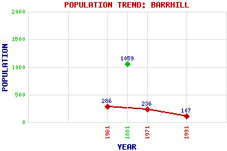
Barrhill Classification and Statistics Settlement Type: village Population (1991): 107 (1971): 236 (1961): 286 (1881): 1059 Tourist Rating: No Text of Entry Updated: 12-JUN-2007 Location Latitude: 55.1009°N Longitude: 4.7648°W National Grid Reference: NX 237 820 A range of modern and historical maps are accessible through the map tab on the right of this page Get directions by entering the UK postcode of your location, home or hotel here eg. EH1 3YT Use the tabs on the right of this page to see other parts of this entry Related Entries There are 36 related entries. (0 Attractions, 1 Council Area, 1 Historical County, 27 Features, 1 Parish, 0 People and 6 Settlements) Names that are not linked do not currently contain any information. Council Area: South Ayrshire Features: Arecleoch Forest Arecleoch Wind Farm Barrhill Railway Station Cairn Hill of the Moil Chirmorie Loch Corrafeckloch Hill Crongart, Loch Dornal, Loch Drumlamford House Drumlamford Loch Duisk River Farroch, Loch Feoch Burn Girvan Academy Goosey, Loch High Derry, Lochs of Kirriemore Loch Kirriereoch Loch Loch Hill Mark Hill Wind Farm Moan, Loch Park Hill Peat Hill Pinmore Viaduct Polmaddie Hill Strawarren Fell Wee Fell Historical Counties: Ayrshire Parishes: Colmonell Settlements: Ballochmorrie Corwar House Girvan Kirriemore Lochton Wheeb Bridge
There are 36 related entries. (0 Attractions, 1 Council Area, 1 Historical County, 27 Features, 1 Parish, 0 People and 6 Settlements)
Names that are not linked do not currently contain any information.
By using our site you agree to accept cookies, which help us serve you better