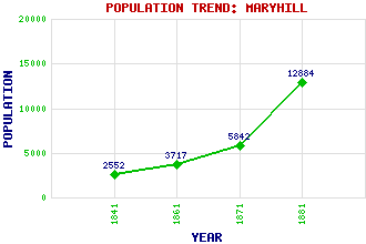
Maryhill Classification and Statistics Settlement Type: suburb Population (1881): 12884 (1871): 5842 (1861): 3717 (1841): 2552 Tourist Rating: No Text of Entry Updated: 31-JUL-2023 Location Latitude: 55.8951°N Longitude: 4.2997°W National Grid Reference: NS 562 692 A range of modern and historical maps are accessible through the map tab on the right of this page Get directions by entering the UK postcode of your location, home or hotel here eg. EH1 3YT References and Further Reading Mitchell, Ian R. (2004) Unlocking Maryhill. Scots Magazine, Vol. 161 No. 2 (Aug. 2004), pp. 175-80. Use the tabs on the right of this page to see other parts of this entry Related Entries There are 38 related entries. (2 Attractions, 1 Council Area, 1 Historical County, 1 Family, 16 Features, 1 Parish, 12 People and 4 Settlements) Names that are not linked do not currently contain any information. Attractions: Forth and Clyde Canal Kelvin Walkway, The Council Area: Glasgow City Families: Graham Features: Dawsholm Dawsholm Bridge Firhill Stadium Gilshochill Glasgow Crematorium Glasgow Golf Course (Killermont) Glasgow Queen Street Railway Station Kelvindale Loch Katrine Aqueduct Maryhill Burgh Halls Maryhill Locks Maryhill Railway Station Maryhill Road Summerston Railway Station Temple Locks Wyndford Historical Counties: Lanarkshire Parishes: Glasgow People: Robert (Bertie) Auld Margaret (Maggie) Bell Thomas (Tommy) Burns Robert Carlyle John Grieve Louisa Jordan Donovan Leitch(Donovan) Duncan Macrae David Keith McCallum James Robert Rhind(J. R. Rhind) Andrew (Andy) Scott Sir Robert Smith(Lord Smith of Kelvin) Settlements: Anniesland Glasgow Possilpark Summerston
There are 38 related entries. (2 Attractions, 1 Council Area, 1 Historical County, 1 Family, 16 Features, 1 Parish, 12 People and 4 Settlements)
Names that are not linked do not currently contain any information.
By using our site you agree to accept cookies, which help us serve you better