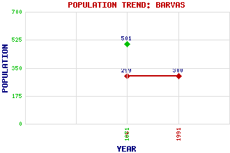
Barvas (Barabhas) Classification and Statistics Settlement Type: hamlet Population (1991): 300 (1961): 299 (1871): 501 Tourist Rating: N/A Text of Entry Updated: 09-MAY-2019 Location Latitude: 58.3586°N Longitude: 6.5135°W National Grid Reference: NB 360 499 A range of modern and historical maps are accessible through the map tab on the right of this page Get directions by entering the UK postcode of your location, home or hotel here eg. EH1 3YT Use the tabs on the right of this page to see other parts of this entry Related Entries There are 22 related entries. (0 Attractions, 1 Council Area, 1 Historical County, 11 Features, 1 Parish, 1 Person and 7 Settlements) Names that are not linked do not currently contain any information. Council Area: Western Isles Features: Barvas Moor Barvas River Barvas, Aird Ben Barvas Lewis More Barvas, Glen More Barvas, Loch Outer Hebrides Roishal More Sheddocksley Tobair, Loch an Historical Counties: Ross and Cromarty Parishes: Barvas People: Helen Denerley Settlements: Borve Lower Barvas Melbost Borve Shawbost Stornoway Upper Barvas Upper Shader
There are 22 related entries. (0 Attractions, 1 Council Area, 1 Historical County, 11 Features, 1 Parish, 1 Person and 7 Settlements)
Names that are not linked do not currently contain any information.
By using our site you agree to accept cookies, which help us serve you better