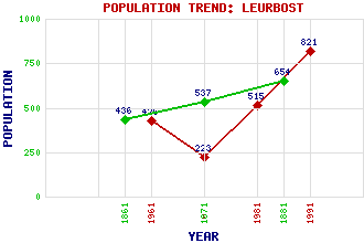
Leurbost (Luerbost, Liurbost, Luirbost) Classification and Statistics Settlement Type: village Population (1991): 821 (1981): 515 (1971): 223 (1961): 426 (1881): 654 (1871): 537 (1861): 436 Tourist Rating: N/A Text of Entry Updated: 30-APR-2020 Location Latitude: 58.1427°N Longitude: 6.4673°W National Grid Reference: NB 372 258 A range of modern and historical maps are accessible through the map tab on the right of this page Get directions by entering the UK postcode of your location, home or hotel here eg. EH1 3YT References and Further Reading Macdonald, Donald (1983) Lewis: A History of the Island. Gordon Wright Publishing, Edinburgh Use the tabs on the right of this page to see other parts of this entry Related Entries There are 16 related entries. (0 Attractions, 1 Council Area, 1 Historical County, 10 Features, 1 Parish, 0 People and 3 Settlements) Names that are not linked do not currently contain any information. Council Area: Western Isles Features: Knock More Soval Leurbost, Loch Lewis with Harris Lochs Nisreaval Nisreaval, Loch Oidraval Orasay Island Soval Steishal Historical Counties: Ross and Cromarty Parishes: Lochs Settlements: Crossbost Soval Stornoway
There are 16 related entries. (0 Attractions, 1 Council Area, 1 Historical County, 10 Features, 1 Parish, 0 People and 3 Settlements)
Names that are not linked do not currently contain any information.
By using our site you agree to accept cookies, which help us serve you better