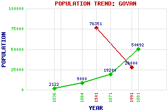
Govan Classification and Statistics Settlement Type: suburb Population (1991): 28000 (1901): 76351(Police Burgh) (1881): 50492 (1871): 19200 (1864): 9000 (1836): 2122 Tourist Rating: Text of Entry Updated: 14-OCT-2007 Location Latitude: 55.8618°N Longitude: 4.3136°W National Grid Reference: NS 553 656 A range of modern and historical maps are accessible through the map tab on the right of this page Get directions by entering the UK postcode of your location, home or hotel here eg. EH1 3YT References and Further Reading Smart, Aileen (1996) Villages of Glasgow: Volume 2 (South of the Clyde). John Donald Publishers Ltd., Edinburgh Use the tabs on the right of this page to see other parts of this entry Related Entries There are 56 related entries. (4 Attractions, 1 Council Area, 1 Historical County, 1 Event, 12 Features, 1 Parish, 32 People and 4 Settlements) Names that are not linked do not currently contain any information. Attractions: Glasgow Underground Govan Old Parish Church Imax Cinema, The Titan Crane, The Council Area: Glasgow City Events: Sinking of HMS Campania Features: BAE Govan Shipyard Bellahouston Park Clyde, River Drumoyne Elder Park Fairfield Fairfield Govan Govan High School Ibrox Linthouse Luma Tower, The Pacific Quay Historical Counties: Renfrewshire Parishes: Govan People: Elish Angiolini George Balfour Sir William Beardmore(Baron Invernairn) Johnnie Beattie Ian Brady(Ian Duncan Stewart) Helen Denerley Sir Patrick Dollan Isabella Elder(Isabella Ure) John Elder Sir Alexander (Alex) Ferguson James Finlayson John MacDougall Hay John M. Honeyman Margo MacDonald David Fowler McIntyre Reg McKay Andrew Melville Bruce Millan Michelle Mone(Michelle Allan, Baroness Mone) Robert Napier James Beaumont Neilson John Neilson Sir William Pearce Sir William George Pearce Dr. James Phemister Sir Robert Philip Percy Sinclair Pilcher James (Jimmy) Reid John Rennie James (Jim) Sillars Alan Spence (Robert) Gordon Wilson Settlements: Clydebank Govanhill Kinning Park Yoker
There are 56 related entries. (4 Attractions, 1 Council Area, 1 Historical County, 1 Event, 12 Features, 1 Parish, 32 People and 4 Settlements)
Names that are not linked do not currently contain any information.
By using our site you agree to accept cookies, which help us serve you better