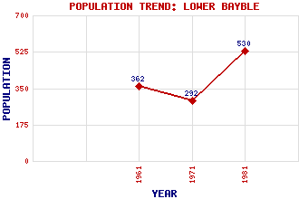
Lower Bayble (Pabail Iarach) Classification and Statistics Settlement Type: hamlet Population (1981): 530 (Combined with Bayble) (1971): 292 (1961): 362 Tourist Rating: No Text of Entry Updated: 30-APR-2020 Location Latitude: 58.1968°N Longitude: 6.2254°W National Grid Reference: NB 518 309 A range of modern and historical maps are accessible through the map tab on the right of this page Get directions by entering the UK postcode of your location, home or hotel here eg. EH1 3YT Use the tabs on the right of this page to see other parts of this entry Related Entries There are 11 related entries. (0 Attractions, 1 Council Area, 1 Historical County, 4 Features, 1 Parish, 0 People and 4 Settlements) Names that are not linked do not currently contain any information. Council Area: Western Isles Features: Bayble Bay Eye Peninsula Lewis Outer Hebrides Historical Counties: Ross and Cromarty Parishes: Stornoway Settlements: Bayble Garrabost Stornoway Upper Bayble
There are 11 related entries. (0 Attractions, 1 Council Area, 1 Historical County, 4 Features, 1 Parish, 0 People and 4 Settlements)
Names that are not linked do not currently contain any information.
By using our site you agree to accept cookies, which help us serve you better