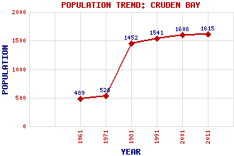
Cruden Bay (Invercruden) Classification and Statistics Settlement Type: village Population (2011): 1615 (2001): 1608 (1991): 1541 (1981): 1452 (1971): 528 (1961): 489 Tourist Rating: No Text of Entry Updated: 18-JAN-2021 Location Latitude: 57.4169°N Longitude: 1.8518°W National Grid Reference: NK 090 363 A range of modern and historical maps are accessible through the map tab on the right of this page Get directions by entering the UK postcode of your location, home or hotel here eg. EH1 3YT Use the tabs on the right of this page to see other parts of this entry Related Entries There are 18 related entries. (2 Attractions, 1 Council Area, 1 Historical County, 5 Features, 1 Parish, 4 People and 4 Settlements) Names that are not linked do not currently contain any information. Attractions: Cruden Bay Golf Course Longhaven Cliffs Reserve Council Area: Aberdeenshire Features: Buchan Bullers of Buchan Cruden, Bay of Cruden, Water of Slains Castle Historical Counties: Aberdeenshire Parishes: Cruden People: Francis Hay(9th Earl of Errol (or Erroll)) King Malcolm II Forbes Simmers Archibald (Archie) Simpson Settlements: Bullers of Buchan Peterhead Port Erroll Whinnyfold
There are 18 related entries. (2 Attractions, 1 Council Area, 1 Historical County, 5 Features, 1 Parish, 4 People and 4 Settlements)
Names that are not linked do not currently contain any information.
By using our site you agree to accept cookies, which help us serve you better