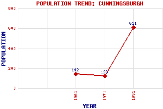
Cunningsburgh Classification and Statistics Settlement Type: village Population (1991): 611 (1971): 126 (1961): 142 Tourist Rating: N/A Text of Entry Updated: 18-FEB-2007 Location Latitude: 60.0533°N Longitude: 1.226°W National Grid Reference: HU 432 301 A range of modern and historical maps are accessible through the map tab on the right of this page Get directions by entering the UK postcode of your location, home or hotel here eg. EH1 3YT Use the tabs on the right of this page to see other parts of this entry Related Entries There are 14 related entries. (0 Attractions, 1 Council Area, 1 Historical County, 8 Features, 1 Parish, 0 People and 3 Settlements) Names that are not linked do not currently contain any information. Council Area: Shetland Features: Aith Voe Cunningsburgh Helli Ness Helliness, Holm of Holm Field Royl Dale Shetland Mainland South Mainland Historical Counties: Shetland Parishes: Dunrossness Settlements: Aithsetter Greenmow Lerwick
There are 14 related entries. (0 Attractions, 1 Council Area, 1 Historical County, 8 Features, 1 Parish, 0 People and 3 Settlements)
Names that are not linked do not currently contain any information.
By using our site you agree to accept cookies, which help us serve you better