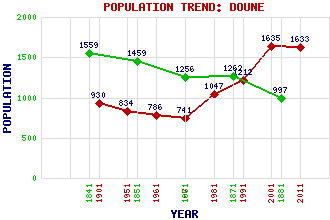
Doune Classification and Statistics Settlement Type: village Population (2011): 1633 (2001): 1635 (1991): 1212 (1981): 1047 (1971): 741 (1961): 786 (1951): 834 (1901): 930(Police Burgh) (1881): 997 (1871): 1262 (1861): 1256 (1851): 1459 (1841): 1559 Tourist Rating: Text of Entry Updated: 30-JUL-2009 Location Latitude: 56.1899°N Longitude: 4.0561°W National Grid Reference: NN 725 016 A range of modern and historical maps are accessible through the map tab on the right of this page Get directions by entering the UK postcode of your location, home or hotel here eg. EH1 3YT Use the tabs on the right of this page to see other parts of this entry Related Entries There are 35 related entries. (2 Attractions, 1 Council Area, 1 Historical County, 12 Features, 1 Parish, 4 People and 14 Settlements) Names that are not linked do not currently contain any information. Attractions: Doune Castle Scottish Antique and Arts Centre (Doune) Council Area: Stirling Features: Annet Burn Ardoch Burn Argaty Blair Drummond Braes of Doune Wind Farm Doune, Braes of Dunblane Railway Station Keir Roundabout Kilbryde Castle Lanrick Mahaick, Loch Teith, River Historical Counties: Perthshire Parishes: Kilmadock People: Thomas Cadell John Grierson Isobel Wylie Hutchison Lieut-Colonel Sir (Archibald) David Stirling Settlements: Blair Drummond Bridge of Allan Buchany Burn of Cambus Callander Deanston Drumvaich Dunblane Gargunnock Lundie Meldrum Row Stirling Thornhill
There are 35 related entries. (2 Attractions, 1 Council Area, 1 Historical County, 12 Features, 1 Parish, 4 People and 14 Settlements)
Names that are not linked do not currently contain any information.
By using our site you agree to accept cookies, which help us serve you better