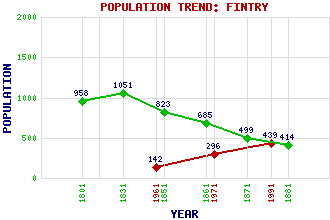
Fintry Classification and Statistics Settlement Type: village Population (1991): 439 (1971): 296 (1961): 142 (1881): 414 (1871): 499 (1861): 685 (1851): 823 (1831): 1051 (1801): 958 Tourist Rating: Text of Entry Updated: 04-JUN-2006 Location Latitude: 56.053°N Longitude: 4.2254°W National Grid Reference: NS 615 867 A range of modern and historical maps are accessible through the map tab on the right of this page Get directions by entering the UK postcode of your location, home or hotel here eg. EH1 3YT Use the tabs on the right of this page to see other parts of this entry Related Entries There are 26 related entries. (0 Attractions, 1 Council Area, 1 Historical County, 1 Family, 11 Features, 1 Parish, 0 People and 11 Settlements) Names that are not linked do not currently contain any information. Council Area: Stirling Families: Graham Features: Ballikinrain Castle Campsie Fells Crow Road, The Culcreuch Castle Drove Hill Earl's Seat Endrick Water Finglen Burn Fintry Hills Holehead Strathendrick Historical Counties: Stirlingshire Parishes: Fintry Settlements: Arnprior Balfron Buchlyvie Cauldhame Falkirk Glasgow Killearn Lennoxtown Muirmill Randieford Stirling
There are 26 related entries. (0 Attractions, 1 Council Area, 1 Historical County, 1 Family, 11 Features, 1 Parish, 0 People and 11 Settlements)
Names that are not linked do not currently contain any information.
By using our site you agree to accept cookies, which help us serve you better