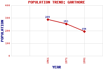
Gartmore Classification and Statistics Settlement Type: village Population (1991): 194 (1971): 253 (1961): 289 Tourist Rating: Text of Entry Updated: 12-JUN-2007 Location Latitude: 56.1436°N Longitude: 4.3804°W National Grid Reference: NS 522 971 A range of modern and historical maps are accessible through the map tab on the right of this page Get directions by entering the UK postcode of your location, home or hotel here eg. EH1 3YT Use the tabs on the right of this page to see other parts of this entry Related Entries There are 21 related entries. (2 Attractions, 1 Council Area, 1 Historical County, 1 Family, 5 Features, 1 Parish, 2 People and 8 Settlements) Names that are not linked do not currently contain any information. Attractions: Loch Lomond and the Trossachs National Park Queen Elizabeth Forest Park Council Area: Stirling Families: Graham Features: Carse of Forth Cunninghame Graham Memorial Forth, River Gartmore House Menteith, Lake of Historical Counties: Perthshire Parishes: Port Of Menteith People: Robert Bontine Cunningham-Graham(Don Roberto) Colonel William Hope Settlements: Aberfoyle Auchentroig Buchlyvie Cobleland Dalmary Garden Port of Menteith Stirling
There are 21 related entries. (2 Attractions, 1 Council Area, 1 Historical County, 1 Family, 5 Features, 1 Parish, 2 People and 8 Settlements)
Names that are not linked do not currently contain any information.
By using our site you agree to accept cookies, which help us serve you better